
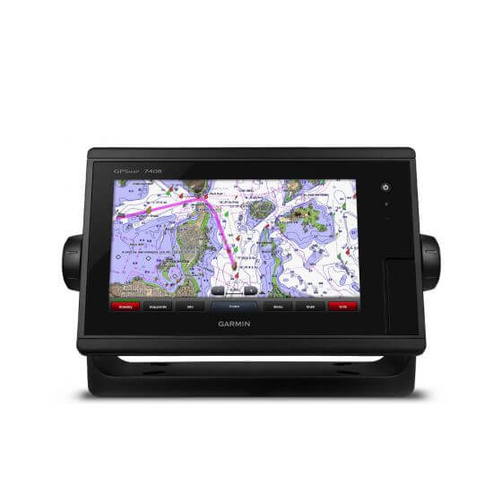
Garmin GPSMAP 7408 Series
Options:
Options
Quantity:
Garmin GPSMAP 7408
Standard Features of the Garmin GPSMAP 7408
XSV
Built in Garmin HD-ID Sonar, true dual-channel CHIRP sonar & both CHIRP ClearVu & SideVu
Supports a Wide range of Garmin Transducers, Including 50/200 kHz, 77/200 kHz, CHIRP (Trad, ClearVu & SideVu)
Supports Panoptix all seeing sonar & GSD & GCV sonar modules
Transmit Power: 1kW RMS (8000 W PTP) CHIRP
Graphic logging of water temprature & sonar recording
Designed for powerboat users, sailors and racing sailors who demand high performance, ease of operation and feature integration, the GPSMAP 7408 chartplotter with 8-inch multi-touch widescreen display has a 10 Hz internal GPS that updates position and heading 10 times per second. It is fully network capable, including the Garmin Network and NMEA 2000, and offers the conveniences of built-in Wi-Fi® connectivity.
Garmin Marine Network and NMEA 2000 Support
Full-network compatibility allows you to add more capabilities to your boat. GPSMAP 7408 supports radar, autopilot, instruments, multiple screens, FUSION-Link, sensors, remote sonar modules, digital switching, thermal cameras, GRID rotary knob, joystick and keypad control and more.Add Extras with BlueChart g2 Vision
With the optional BlueChart g2 Vision, you can add a whole new dimension of exceptional features to your chartplotter. MarinerEye view and FishEye view provide a 3-D perspective, both above and below the waterline. High-resolution satellite images and aerial photographs help orient you in unfamiliar areas. Auto Guidance technology searches through all relevant charts to create a route you can actually follow — one that avoids obstacles, shallow water, buoys and other obstructions.Special Sailing Features
Supported sailing features include laylines, enhanced wind rose, heading and course-over-ground lines, true wind data fields and tide/current/time slider. Gauge displays are designed to provide important need-to-know information at a glance, including true and apparent wind angle, set and drift, true or apparent wind speed, horizontal or vertical graphs, and a data bar with customisable data fields.Garmin Marine Network and NMEA 2000 Support
Full-network compatibility allows you to add more capabilities to your boat. GPSMAP 7408 supports radar, autopilot, instruments, multiple screens, FUSION-Link, sensors, remote sonar modules, digital switching, thermal cameras, GRID rotary knob, joystick and keypad control, and more. GPSMAP 7408 allows you to share features with other compatible GPSMAP units, such as radar, GSD 24, GSD 26 sonar modules, supplemental maps, and user data, including waypoints, routes and tracks. User data entered into 1 chartplotter can be automatically synced with other chartplotters in a network.Heading and Position Refreshed 10 Times Per Second
Fast, responsive 10 Hz GPS/GLONASS refreshes your position and heading 10 times each second to make your movement on the screen more fluid. It makes dropping up to 5,000 accurate waypoints — and finding your way back to them — quick and easy.Compatible with gWind™ Transducers
Garmin gWind, gWind Wireless and gWind Race transducers feature twin-fin technology with 3-bladed propeller. Connect to the NMEA 2000 and compatible Garmin chartplotters via the GND™ 10 black box bridge.*FUSION-Link Entertainment System
Enjoy the ability to control all compatible FUSION-Link-enabled audio systems directly from your compatible chartplotter display.Built-in Wi-Fi/ANT
For use with BlueChart Mobile and Garmin Helm.View and Control Your Device from a Smartphone or Tablet
Garmin Helm allows you to view and control your compatible Garmin chartplotter from a compatible smartphone or tablet while providing enhanced situational awareness for the mariner. Easily switch between portrait and landscape mode to accommodate mounting preferences. When using an iPhone® or iPad®, you can even record a movie of your chartplotter screen to share with friends and family. Download from The App Store™ or Google Play™.Get Your Apple® Device Onboard with BlueChart Mobile
With BlueChart Mobile, a free app downloaded from the App Store, you can plan marine routes on your iPad or iPhone then wirelessly transfer them to your boat’s compatible networked Garmin chartplotter. Even if you don’t have a Garmin chartplotter, you can still take advantage of the tremendous features of BlueChart on your Apple device. iPhone and iPad are trademarks of Apple Inc. App Store is a service mark of Apple Inc. Android and Google Play are trademarks of Google Inc. Wi-Fi is a registered trademark of the Wi-Fi Alliance. * Transducers Sold Separately (see related products to add your chosen transducer to your order)In The Box
- GPSMAP 7408 J1939
- J1939 connector which offers a dedicated CAN port for receiving engine data
- Power/data cable
- NMEA 2000® drop cable
- T-connector
- Bail mount with knobs
- Flush mount kit
- Protective cover
- Documentation
